Sign Up. Stay Informed.
Data Tools
CPRA developed two new interactive data tools to complement the 2023 Coastal Master Plan: the Master Plan Data Viewer (MPDV)and the Master Plan Data Access Portal (MP-DAP). The Master Plan Data Viewer facilitates effective communication by providing a user-friendly way to visualize potential changes across coastal Louisiana with, and without, the master plan 50 years into the future. The Master Plan Data Access Portal was developed to enable online visualization and download access to many of the modeling data sets used to develop the 2023 Coastal Master Plan. Please see below for more information on each tool.
2023 Master Plan Data Viewer (MPDV)
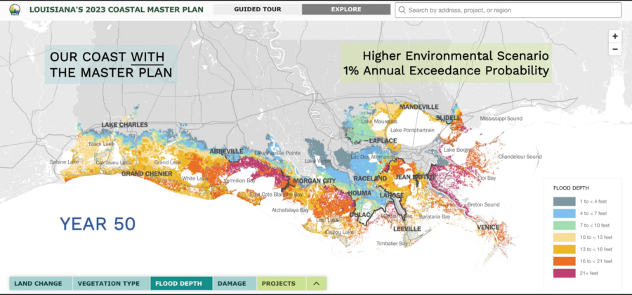
The MPDV was first introduced as a supplemental tool to the 2017 Coastal Master Plan. This tool makes results from the 2023 Coastal Master Plan analyses accessible online. The MPDV, which is an interactive companion to the plan, includes information on land change, vegetation type, flood depth, damage, and projects that helps viewers visualize what change might look like over time in their communities and across the coast.
Important updates to the Master Plan Data Viewer include:
- Incorporation of the most up to date model outputs at a higher resolution
- Improved user experience including a Guided Tour feature on the landing screen to provide context and to improve the usability of the information for coastal Louisiana residents
- Increased accessibility with the viewer now easily accessed on mobile phones and tablets
- Added search bar functionality that allows users to search for keywords, such as part of project name or their town
- Additional features include:
- new zoom and highlighting functions
- map export function to facilitate easy printing
- expanded data download capabilities via the Master Plan Data Access Portal
To view the Master Plan Data Viewer (MPDV), click here.
Master Plan Data Access Portal (MP-DAP)
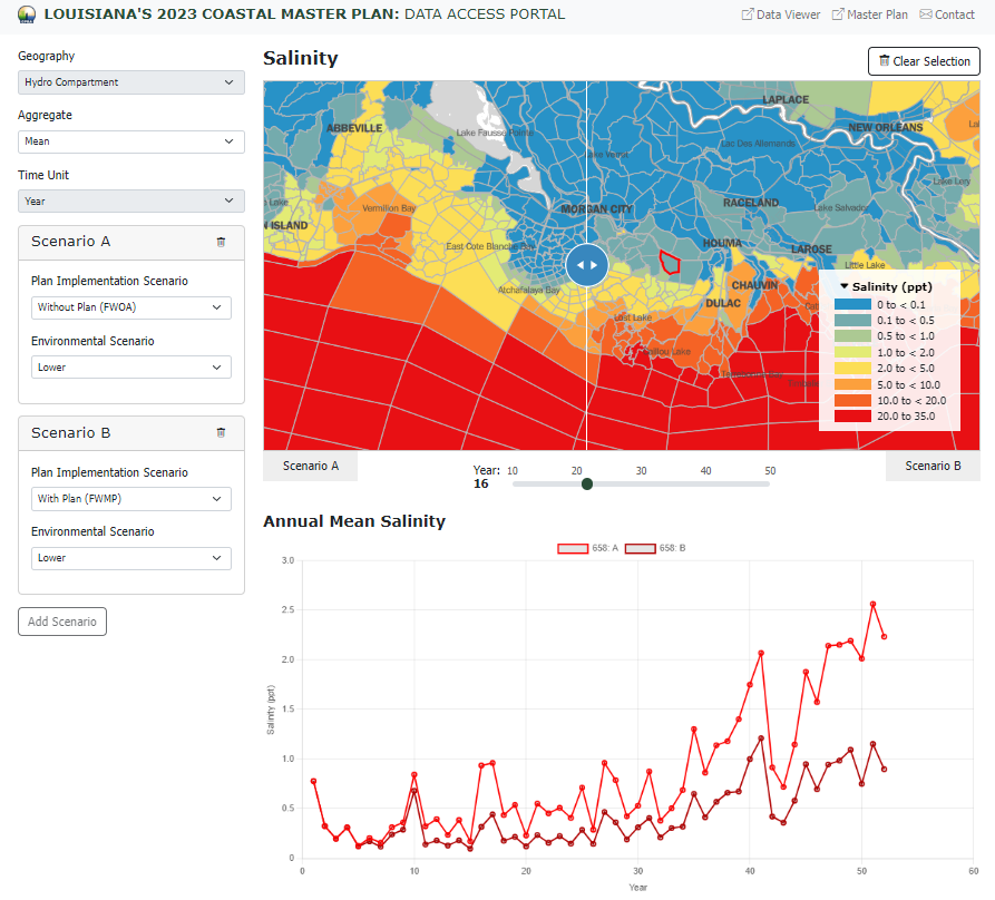
The MP-DAP is a new interactive data tool and central location for all of the modeling data sets used to develop the 2023 Coastal Master Plan. The MP-DAP builds off of the Master Plan Data Viewer and further enhances data access and transparency. The portal is intended for those who already have a good grasp on the types of master plan data and their application allowing researchers, academics, and practitioners of all types to be able to dig deeper into the data and select a variety of variables for online visualization. These images are able to be exported, or users can download the data and create graphics to meet their specific needs.
Examples of currently available data includes land change, vegetation type, flood depth, storm surge-related damages, salinity, and water level. The portal also includes documentation to explain metadata, links to reference documents, and model geometries. Further data sets and functionality will be forthcoming.
To view the Master Plan Data Access Portal (MP-DAP), click here.