
Sign Up. Stay Informed.
Eden Isle Flood Risk Reduction
Background
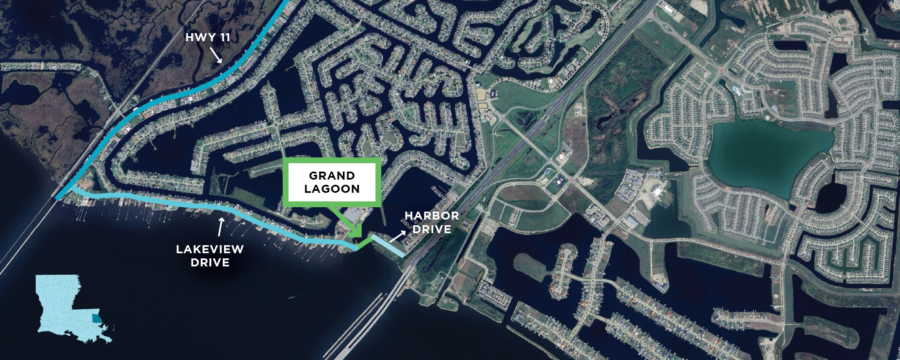
Eden Isle, Louisiana, a access community on the northern rim of Lake Pontchartrain, is vulnerable to coastal flooding, especially during storm surge events. To address this, CPRA conducted a feasibility study outlining key structural needs for the area, and findings were shared with the St. Tammany Levee, Drainage and Conservation District (STLDCD) and the St. Tammany Parish Government in June 2026. The feasibility study proposes risk reduction solutions for three critical project areas: Grand Lagoon, Harbor Drive, and Lakeview Drive.
For each project area, the study provides alternatives for flood risk reduction. The alternatives were proposed to ensure that the locals of Eden Isle and leaders in St. Tammany Parish can collectively agree on which kind of project is best for the given area.
CPRA is committed to providing +11 ft risk reduction to the Eden Isle Community in conjunction with the following requirements:
- St. Tammany Parish government and STLDCD mutually agree on preferred alternatives and present to CPRA
- St. Tammany Parish must develop and revenue plan to fund construction and long-term operation and maintenance of the desired alternative structure
- Engage DOTD to raise Hwy. 11 to at least +11 ft. risk reduction
Grand Lagoon
During the feasibility study, CPRA concluded that a floodgate was essential to the preservation of Grand Lagoon due to numerous properties having waterfront access on Lake Pontchartrain. A floodgate would complete the system, closing the gap between Lakeview Drive and Harbor Drive, providing +11.0 ft risk reduction. The study recommended that a barge gate would be most appropriate for the project area.
Floodgate Details:
- Constructs a barge gate with an opening of 40 ft – 90 ft, with final opening size to be analyzed and determined in engineering and design phase.
- The gate will remain open to allow navigable passage, but will close when necessary for storm surge and risk reduction.
- Estimated Cost: $36M – $43M

Floodgate example
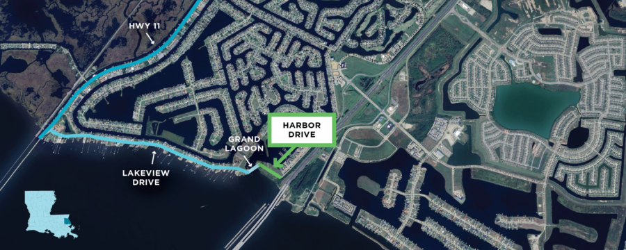
Harbor Drive
Harbor Drive sits at the easternmost portion of Eden Isle between the entrance to Grand Lagoon and I-10. The area is undeveloped, with a deteriorated bulkhead along the edge of Lake Pontchartrain. There are 3 alternatives for the Harbor Drive component of the Eden Isle Flood Risk Reduction all of which include one-way culverts for maintenance of drainage west of I-10 into Lake Pontchartrain.
Alternative A: Elevate Harbor Drive
- Raises Harbor Drive in its current location or placement of a floodwall in the center of Harbor Drive to the target protection level of +11.0 ft.
- Estimated Cost: $4M – $8.7M
Alternative B: Earthen Levee
- Constructs an earthen levee south of Harbor Drive, minimizing roadway impacts to Harbor Drive.
- Estimated Cost: $1M – $9M
Alternative C: Replace Existing Bulkhead
- Requires full reconstruction of the existing bulkhead along the lakefront to serve as flood protection.
- Estimated Cost: $19.6M
Lakeview Drive
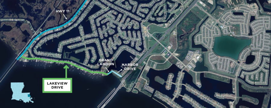
Lakeview Drive is the southernmost segment of the Eden Isle neighborhood, serving as the barrier between Lake Pontchartrain and the rest of the development. This 1.5-mile stretch is populated with waterfront properties and extremely vulnerable to storm surge inundation and flooding. CPRA has designed 4 alternatives for how to address flood risk reduction and protect Lakeview Drive and Eden Isle.
Alternative A: 2-Lane Road
Raises Lakeview Drive as a two-lane roadway with one lane on each side of a centerline barrier. Construction would be completed in two phases and may require utility relocation and steeper incline for driveways. Phase 1 would elevate the roadway to +8.5 ft and Phase 2 would install a centerline floodwall to reach +11.0 ft.1.0 ft.
- Land Acquisition: Partial
- Utility Relocation: Yes
- Traffic Impacts: Roadway size and wall limit normal traffic function; requires turnaround installations
- Homeowner Impacts: Steep incline required for driveways; minor impact to lakefront view (2.5 ft wall)
- Estimated Cost: $43M-54M
Alternative B: 4-Lane Road
Raises Lakeview Drive to +6.0 ft as a four-lane divided roadway with two opposite traveling lanes on each side of a centerline barrier to reach +11.0 ft. Construction may require utility relocation and the acquisition of residential driveway space.
- Land Acquisition: Partial
- Utility Relocation: Yes
- Traffic Impacts: Two-lanes on either side of the floodwall allow more normal traffic flow
- Homeowner Impacts: Limited space between homes and roadway; Limits lakefront view (5 ft wall)
- Estimated Cost: $63M-$69M
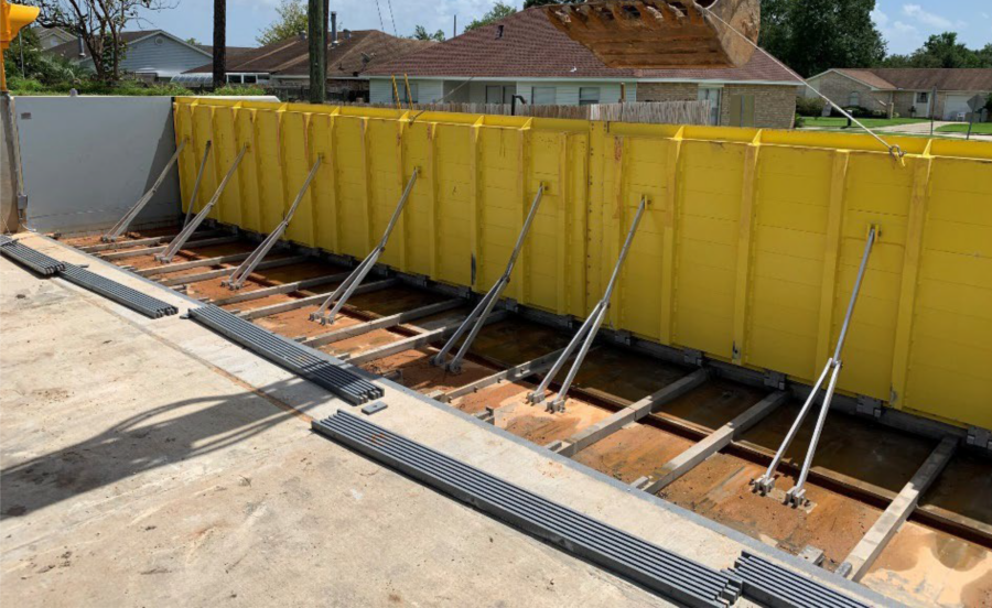
Alternative C: Floodbreak
Raises Lakeview Drive as a two-lane roadway with automated risk reduction. Construction would be completed in two phases where Phase 1 would elevate the roadway to +8.0 ft and Phase 2 would install self-deploying flood barriers to reach +11.0 ft.
- Land Acquisition: Partial
- Utility Relocation: Yes
- Traffic Impacts: Traffic will be able to cross the floodwall only when retracted and hard tie-in structures will be required along where the road turns
- Homeowner Impacts: Steep incline required for driveways
- Estimated Cost: $143M
Alternative D: Earthen Levee
Constructs a continuous earthen levee north of Lakeview Drive in lieu of roadway elevation to reach +11.0 ft of protection. Alternative D would require the acquisition of properties and homes north of Lakeview Drive.
- Land Acquisition: Full acquisition of all homes and properties north of Lakeview Drive + north or south of Northshore Circle depending on final alignment
- Utility Relocation: Partial
- Traffic Impacts: Does not affect existing roadway
- Homeowner Impacts: Buyout required for all homes north of Lakeview Drive + north or south of Northshore Circle depending on final alignment
- Estimated Cost: $58M-$59M
Floodbreak example