November 1, 2018
Michael DeMocker/The Times-Picayune
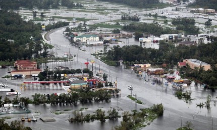
US 51 at I-10 in LaPlace is covered with floodwaters in the aftermath of Hurricane Isaac on Aug. 30, 2012
Resilient Coast, Resilient People
If one thing defines Louisiana’s coastal residents, it’s our ability to bounce back from difficulties – our resilience and our fortitude. For hundreds of years, indigenous and immigrant populations, comprised of intrepid and hard-working individuals, have made their homes and their livelihoods alongside an ever-changing coast, facing adversity with an unflinching resolve. We celebrate all that is good about the coast and brace for the worst of what the weather brings. When faced with unspeakable tragedies like hurricanes, we rebuild our lives and continue to thrive, all the while growing coastal Louisiana into the economic engine and cultural melting pot that it is today. The Louisiana coast is a reflection of the people who call it home – dynamic and unique. Our coast is facing real threats right now, and with so much at stake, it can seem like an insurmountable challenge. However, there is hope for a bright future.
In 2012, areas of LaPlace, Louisiana experienced devastating floods associated with Hurricane Isaac, and more than 7,000 homes in the area were impacted by the storm surge from Lake Pontchartrain. This exemplifies a prime opportunity to improve resilience in a coastal area to reduce risk for people who live and work in impacted areas just west of New Orleans. As part of the Louisiana’s 2017 Coastal Master Plan, the West Shore Lake Pontchartrain Hurricane Risk Reduction project aims to provide increased protection to people and property in surrounding areas such as LaPlace, Reserve and Garyville and once implemented, which translates to reduced storm-surge related flooding. Funded as part of the Hurricane & Storm Damage Risk Reduction System (HSDRRS), the West Shore project will provide an added layer of defense to residents in and around LaPlace, and will also improve resilience of communities on the western shores of Lake Pontchartrain and Lake Maurepas.
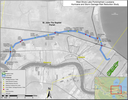
Seen on this map in blue, the $760 million West Shore project will construct approximately 18 miles of earthen levees and floodwalls, four floodgates, two drainage structures and four pump stations along the levee. The levee will start at the Mississippi River in Garyville and end at the Bonnet Carre Spillway outside LaPlace. Though not pictured on this map, there’s an earthen berm and several non-structural protection measures that will be included for communities in St. James Parish just west of what you see on this map.
Achieving Greater Impact with Multiple Projects
The West Shore project will benefit more than 60,000 residents from Garyville to LaPlace, and it is also one project in part of a larger plan to help reduce risk and improve resiliency for this region. Solving a complex problem often requires multi-faceted solutions, which is why CPRA emphasizes projects working together to achieve the greatest benefit. For instance, marsh restorations and levee protection systems are great examples of how a restoration project and a risk reduction project can work in tandem to deliver protection against tropical storm surge.
For the West Shore project, project synergy will come in the form of a shared border with the River Reintroduction into Maurepas Swamp project, which will reestablish and nourish approximately 45,000 acres of the swamp with freshwater, nutrients and sediment from the Mississippi River that historically sustained the swamp. Together, these projects will provide a greater level of protection than alone. The West Shore Project will provide an initial line of defense to knock down storm surge and the Maurepas Swamp project will provide a robust and healthy swamp that will act as an added buffer to further reduce the storm surge flood impact for low-lying areas.
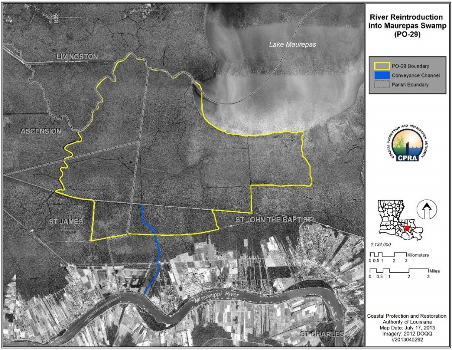
The Maurepas Swamp project, highlighted in yellow, will introduce nutrient-rich water from the Mississippi River into the swamp area through the blue channel.
Why are these projects so vital now?
With an increasing population due to suburban and industrial development along the river corridor between Baton Rouge and New Orleans, more people and businesses are susceptible to damages from tropical storm surge than ever before. As Hurricane Isaac demonstrated, communities on the west shore of Lake Pontchartrain are also at an increased risk to tropical storm surge flooding due to wetland loss and relative sea level rise.
Reducing Risk, Reducing Costs
CPRA estimates that by year 50, with the implementation of this project, expected annual damages (EAD) will be reduced by $865 million. This represents enormous savings for area residents and the state. To read more about EAD, check out the Master Plan fact sheet for this project by clicking here.
While the devastation from tropical storm surge flooding has significant economic impacts on a community (to say nothing of the human suffering and loss of homes and businesses), flooding also presents significant everyday costs to families and businesses. As coastal residents are well aware, flood insurance can be an enormous expense, often too much to afford for some families. The areas impacted by Isaac required flood insurance before the storm, and according to The New Orleans Advocate, annual flood insurance rates jumped by approximately 400 percent in some impacted areas after the storm. Parish officials believe these new measures to protect residents from flooding may help reduce these high flood insurance costs. This translates to more dollars in the pockets of area residents and lower costs for business owners.
Louisianans will always remain strong in the face of adversity, but projects such as this one will lessen our need to do so.
Become a Coastal Advocate!
Learn more about your current and future flood risk.
Visit the Master Plan Data Viewer and CPRA Resources.
Click here to subscribe to our blog and coastal updates.
Connect with Us! @LouisianaCPRA