Between 1932 and 2016 Louisiana‘s coast lost 2,006 square miles of land.
It is time for an innovative, science-based solution.
Between 1932 and 2016 Louisiana‘s coast lost 2,006 square miles of land.
It is time for an innovative, science-based solution.
Addressing Louisiana's Land Loss Crisis
What Happened?
Between 1932 and 2016, coastal Louisiana‘s lost over 2,000 square miles of land. Between 2004 and 2008 alone, more than 300 square miles of marshland were lost to Hurricanes Katrina, Rita, Gustav, and Ike.
But why? There are several factors contributing to our severe and detrimental land loss crisis, including sea level rise, subsidence, saltwater intrusion, manmade contributions, the Deepwater Horizon oil spill and subsequent response activities, and side effects of our current levee system. While our levees provide critically important flood protection to our coastal communities, they have also cut off the Mississippi River from Barataria Basin and Breton Sound Basin, restricting it from depositing sediment and nutrients into those basins. Without this natural process, our coast is starved of the nutrients and sediment needed to sustain healthy wetlands.
LA's Coast: 1920
LA's Coast: Today
An additional 2,250 square miles could be lost over the next 50 years if we do nothing to address our land loss crisis.
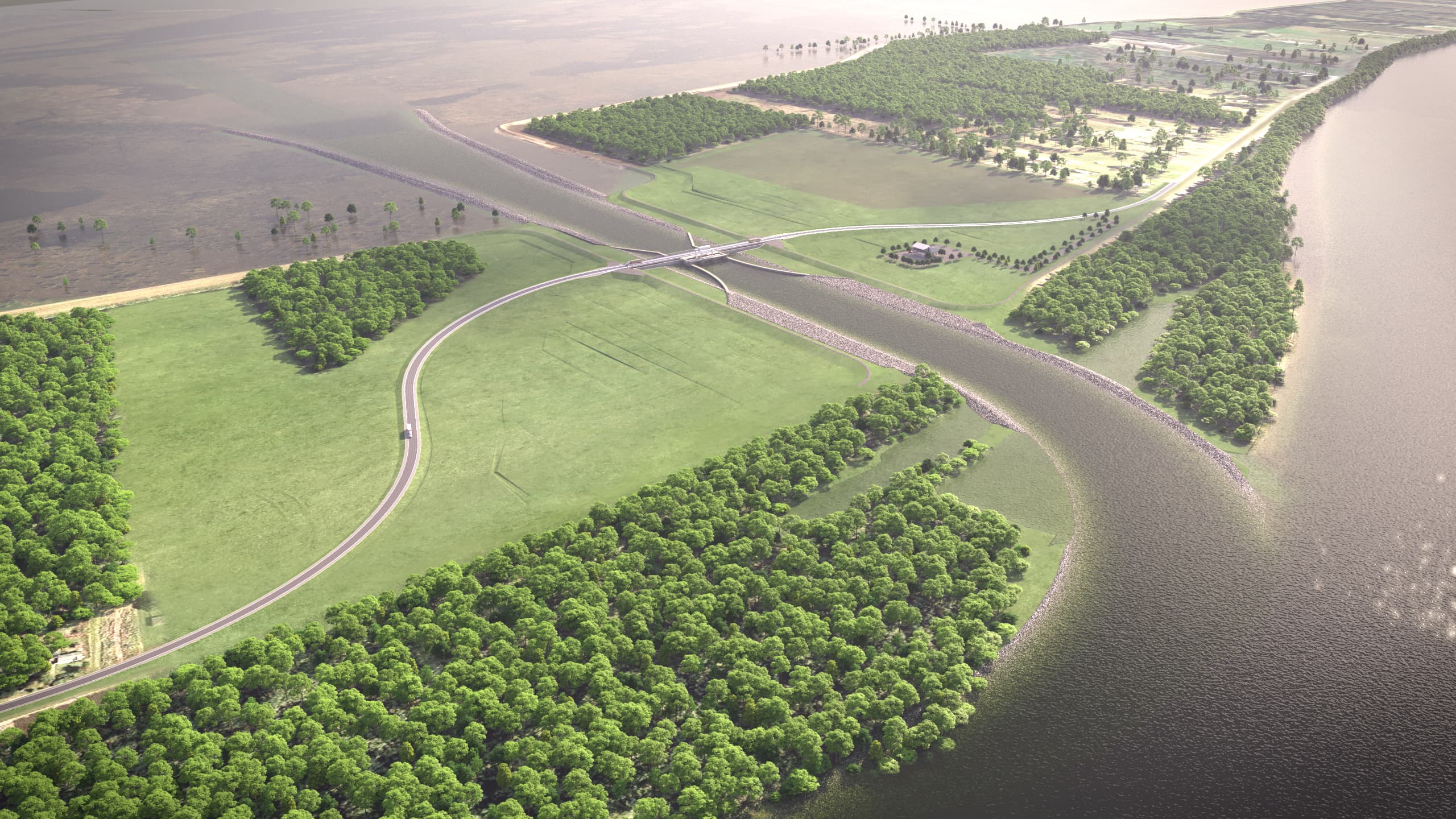
Mid-Barataria Sediment Diversion
Plaquemines Parish
The Mid-Barataria Sediment Diversion, located on the west bank of the Mississippi River, is a first-of-its-kind coastal restoration project that, once complete, will become one of the largest environmental infrastructure projects in the history of the United States.
Louisiana’s coastal wetlands are some of the fastest disappearing land masses on earth.
What do we do about it?
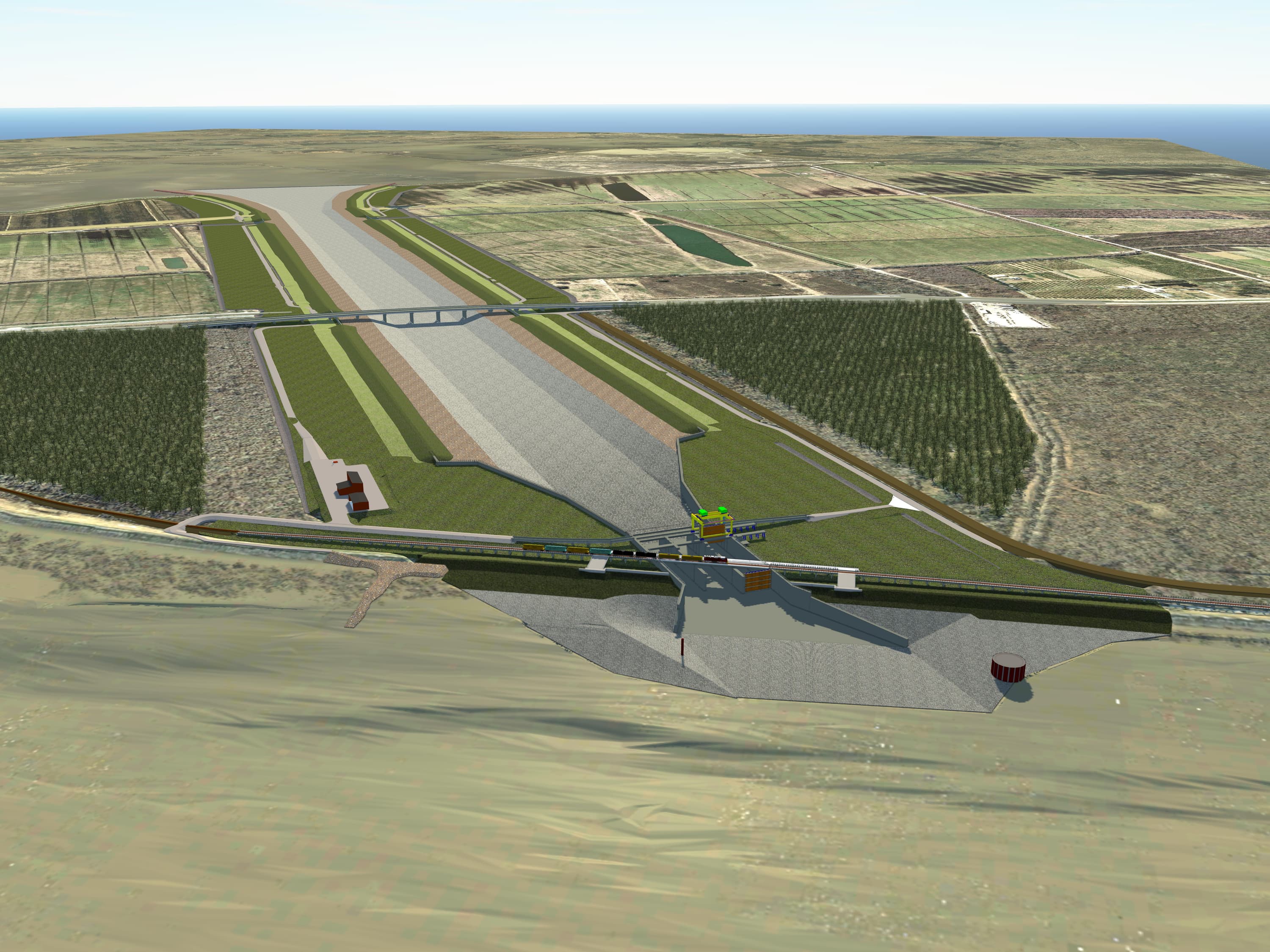
Reconnect the river
To address the root cause of our rapid coastal land loss, we have to restore the natural processes that originally built our state by “reconnecting the river.” Sediment diversions are controlled structures that use “engineering with nature” to mimic the natural land building processes. These projects offer a unique solution to strategically re-establish hydrologic flows, carry land-building sediment, nourish marshes, and sustain land.
When implemented with the full suite of projects outlined in the Coastal Master Plan, including marsh creation and dredging, sediment diversions contribute to an integrated systems approach at restoring and protecting coastal Louisiana. Utilizing every “tool in our toolbox” is our best chance to combat our land loss crisis.
Mid-Breton Sediment Diversion
Plaquemines Parish
The Mid-Breton Sediment Diversion is a cornerstone project of Louisiana’s Coastal Master Plan. The project is currently in the early stages of the federal permitting process and will work to restore the Breton Sound basin, located on the east bank of the Mississippi River.
Louisiana’s coastal wetlands are some of the fastest disappearing land masses on earth.
Addressing Louisiana's Land Loss Crisis
What Happened?
Between 1932 and 2016, coastal Louisiana‘s lost over 2,000 square miles of land. Between 2004 and 2008 alone, more than 300 square miles of marshland were lost to Hurricanes Katrina, Rita, Gustav, and Ike.
But why? There are several factors contributing to our severe and detrimental land loss crisis, including sea level rise, subsidence, saltwater intrusion, manmade contributions, the Deepwater Horizon oil spill and subsequent response activities, and side effects of our current levee system. While our levees provide critically important flood protection to our coastal communities, they have also cut off the Mississippi River from Barataria Basin and Breton Sound Basin, restricting it from depositing sediment and nutrients into those basins. Without this natural process, our coast is starved of the nutrients and sediment needed to sustain healthy wetlands.
LA's Coast: 1920
LA's Coast: Today
An additional 2,250 square miles could be lost over the next 50 years if we do nothing to address our land loss crisis.
What do we do about it?
Reconnect the river
To address the root cause of our rapid coastal land loss, we have to restore the natural processes that originally built our state by “reconnecting the river.” Sediment diversions are controlled structures that use “engineering with nature” to mimic the natural land building processes. These projects offer a unique solution to strategically re-establish hydrologic flows, carry land-building sediment, nourish marshes, and sustain land.
When implemented with the full suite of projects outlined in the Coastal Master Plan, including marsh creation and dredging, sediment diversions contribute to an integrated systems approach at restoring and protecting coastal Louisiana. Utilizing every “tool in our toolbox” is our best chance to combat our land loss crisis.
Mid-Barataria Sediment Diversion
Plaquemines Parish
The Mid-Barataria Sediment Diversion, located on the west bank of the Mississippi River, is a first-of-its-kind coastal restoration project that, once complete, will become one of the largest environmental infrastructure projects in the history of the United States.
The Mid-Breton Sediment Diversion is a cornerstone project of Louisiana’s Coastal Master Plan. The project is currently in the early stages of the federal permitting process and will work to restore the Breton Sound basin, located on the east bank of the Mississippi River.
 Learn More